


- Home
- Things To Do
- Parks & Outdoors
- Parks
- Tyrrell Park
- Tyrrell Park Nature Center
- Gift Shop
- Big Thicket
- The Best Hiking Trails in the Big Thicket
- Water Activities
- Lakes and Rivers
- Neches River Boat Tours
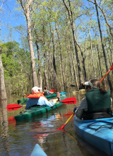
- Kayaking and Canoeing in Beaumont
- Horseback Riding
- Botanical Gardens
- Beaumont in Bloom
- Fishing & Hunting
- Fishing Charters in Beaumont
- Golf
- Camping in Beaumont
- Agritourism
- Hiking
- Biking
- Beaucycles
- Birding
- Cattail Marsh
- Big Thicket
- Birding Package
- Beaumont Birdies
- Birder Mailing List
- Anahuac
- High Island
- Bolivar Flats
- Sabine Woods
- Galveston Island
- Creole Nature Trail
- Swamps & Gators
- Arts & Culture
- Performing Arts/Theater
- Galleries & Museums
- Murals and Visual Art
- 10 Best Instagram Spots
- SETX Selfie Scavenger Hunt
- Museums & Historic Sites
- Top Historic Spots
- Spindletop
- Museums
- Historic Homes
- Entertainment & Nightlife
- Casinos & Gaming
- Happy Hour
- Live Music
- Movie Theaters
- Bowling & Skating
- After Hours
- Sawdust Saloon
- Shopping
- Antiques
- Boutiques
- Gift Guide
- GoBeau Gifts
- Bolivar Beach
- Cattail Marsh
- Web Cam
- Wetlands Education Center
- Volunteer
- Roadside Attractions
- Things to Do with Kids
- Parks & Playgrounds
- Bowling & Skating
- Things to Do for Couples
- Girlfriend Getaway Ideas
- Things to Do Solo
- Dog-Friendly Attractions
- Beaumont Bucket List
- Bucket List Challenge
- LGBTQ Guide
- Geocaching
- 24-Hour Itinerary
- Wheelchair-Accessible Guide
- Multigenerational Itinerary
- Black History and Culture
- Home
- Restaurants
- Eat Local #EATBMT
- BBQ
- Burgers
- Mediterranean & Indian
- Tex-Mex
- Margaritas
- Pasta
- Pizza
- Sandwiches
- Seafood
- Street Tacos
- Sushi
- Vietnamese
- Family Friendly Restaurants
- Bars, Pubs & Breweries
- Breweries
- Wineries
- Dive Bars
- Sports Bars
- Outdoor Bar Scene
- Live Music
- Bakery & Cafe
- Happy Hour
- Best Beaumont Bites
- Patio Restaurants
- A-Z: A South Texas Cajun Food Guide
- Crawfish Spots
- Where to Find Gumbo
- Instagram Foods
- Favorite Foodie Restaurants
- Cajun Trail
- Cajun Trail FAQ
- Home
- Plan
- Visitors Guide
- Top 10 Reasons to Visit
- Trip Ideas
- Texas History Trail
- Faith Trail
- Black Gold Trail
- Pioneer Trail
- Adventure Seekers
- Festival Lovers
- 24-Hour Guide
- Nature Trail
- Insider's Guide
- Visitor Center
- Maps
- Transportation
- Jack Brooks Airport
- Weather
- eNewsletter
- Webcams
- FAQ
- Deals
- GoBeau
- Home
- Events
- Event Calendar
- Annual Events
- February: Mardi Gras of Southeast Texas
- March: Taste of the Triangle
- March: South Texas State Fair & Rodeo
- April - 409 Weekend
- April- Neches River Festival
- May- Neches River Rally
- October: Oktoberfest
- October: Dogtober Fest
- October: Museum Madness
- October- The Haunted Hotel
- December: Main Street Market
- December: Holidays in Beaumont
- December: Christmas in Boomtown: City in Lights
- Beaumont Mardi Gras
- Carnival
- Concerts
- Mardi Gras Attractions
- Capes and Crown 5K
- How to Get Involved
- Classic Movie Nights
- Farmers Market
- Neches River Boat Tours
- Submit Your Event
- Event Submission Policy
- Recurring Events
- Downtown Beaumont Junk Days
- Larry's Old Time Trade Days
- I-10 Flea Market
- Events This Weekend
Big Thicket
Piney Woods
The piney woods in the Big Thicket is much different than coastal Texas and thus has a totally different mix of species. A patchwork of protected areas has created a convergence of ecosystems ranging from longleaf pine forests to cypress rimmed bayous, resulting in some of the greatest diversity north of the equator. The trail network could keep you busy for days from the 15-mile Turkey Creek Trail and to the 2.5-mile Kirby Trail, but kayaking or paddling is another popular way to explore.
Neotropical migrants navigate across the Gulf to nest at this location in winter and spring. Common sightings include Swainson’s, Prothonotary, Hooded, and Yellow-throated Warblers, Yellow-billed Cuckoo, Great Crested and Acadian Flycatchers, White-eyed, Red-eyed, and Yellow-throated Vireos, Summer Tanager, and many others. The winter brings mixed foraging flocks of Ruby-crowned and Golden-crowned Kinglets, Blue-headed Vireo, and Pine and Yellow-rumped Warblers. Other species such as Yellow-bellied Sapsucker, Brown-headed Nuthatch, Eastern Bluebird, Hermit Thrush, and Eastern Towhees are also common in winter.
• Major Birding Sites: Kirby Nature Trail, Firetower Road, Turkey Creek Trail, Roy E. Larsen Sandyland Sanctuary, Village Creek State Park
Headquarters Area
Just east of the Big Thicket National Preserve visitor center and headquarters lies an expanse of wetland pine savannah known informally as the Solo Tract. There are no trails in this area, but visitors are welcome to wander among the longleaf pines and look for birds, wildflowers, and carnivorous plants.
From the visitor center, walk or drive east along FM 420 to the second driveway on the left. Walk around the locked gate to enter this area.
Birding Resources
Pick your Trail:
Short: Sundew Trail, Pitcher Plant Trail, Beechwoods Trail, Beaver Slide Trail
Moderate: Kirby Nature Trail and Sandhill Loop Trails, Woodlands Trail, parts of the Turkey Creek Trail
Longer: Turkey Creek Trail, Big Sandy Trail
Accessible Trails: Inner Loop of the Sundew Trail; first quarter-mile of the Pitcher Plant Trail to the pitcher plant bog
Kirby Nature Trail
Three loop options, ranging from 1.5 to 2.5 miles, pass through several plant communities, from baygalls to cypress sloughs to the riparian zone along Village Creek. An interpretive trail guide is available at the visitor center for a small charge.Hikers can continue north from this trail to the Sandhill Loop Trail and the Turkey Creek Trail. The trailhead is located on FM 420, 2.5 miles east of the visitor center.
Sandhill Loop Trail
From the Kirby Nature Trail, cross the bridge over Village Creek and follow the Turkey Creek Trail north for 0.8 mile to reach the Sandhill Loop Trail. This trail makes a loop of 1.3 miles through a forest of longleaf pines. Turkey Creek Trail Six trailheads provide access to different parts of this 15-mile trail. Hikers can access this trail on FM 1943, 3.5 miles east of Warren; at the Pitcher Plant Trail, 2 miles south of FM 1943 on CR 4850; on CR 4825; along the Gore Store Road, 4 miles east of Hwy 69; and on FM 420 at the Kirby Nature Trail.
Pitcher Plant Trail
The first quarter-mile of the Pitcher Plant Trail passes through longleaf pines into a large bog of pitcher plants and sundews. The 1-mile trail continues through a mixed woodland, joining the Turkey Creek Trail before looping back to the trailhead. The trailhead is on CR 4850, about 2 miles south of FM 1943 and about 4.5 miles east of Warren.
Sundew Trail
Both the inner 0.3-mile loop and the outer 1-mile loop pass through a small bog of pitcher plants. The inner loop continues through a savannah that has abundant summer wildflowers, while the outer loop winds through a woodland composed primarily of longleaf pines. One of the best places in the preserve to see birds and wildflowers, as well as the tiny red sundew plants.The trailhead is on CR 1910, 0.5 mile south of FM 2827 and approximately 7 miles north of the visitor center.
Beechwoods Trail
Hikers in the Beech Creek Unit can follow either the Beech Woods Trail, which makes a 1-mile loop, or a former dirt road that extends from the trailhead for 6 miles through the unit. The Beech Woods Trailhead is located on FM 1992, 1.5 miles north of FM 1013.
Beaver Slide Trail
The Beaver Slide Trail makes a loop of 1.5 miles near Big Sandy Creek. It is heavily wooded and is an excellent short hike on which to see cypress trees. A map of this trail is included on the Big Sandy Trail map, below. The trailhead is on FM 943, approximately 0.25 miles west of the intersection with FM 1276.
Big Sandy Trail
The Big Sandy Trail has more topography than other trails in the preserve, and goes through many different ecosystems along its 9-mile length. It is the only trail in the preserve that is open to horseback riding and bicycling as well as hiking. The trailhead is on the Sunflower Road, 3 miles west of FM 1276 near Dallardsville.
Woodlands Trail
The Woodlands Trail consists of three loops of 3.3 miles, 4.5 miles, and 5.4 miles, giving hikers several distance options. This trail traverses a variety of plant communities, including the Big Sandy Creek floodplain and dense stands of hardwood trees. A map of this trail is included on the Big Sandy Trail map, above. The Woodlands Trailhead is located on FM 1276, 5.9 miles north of Dallardsville and 3.3 miles south of US 190.
Birdwatchers' Trail
This 0.5-mile trail, located at the confluence of Menard Creek and the Trinity River, provides good views of the sandbars along the Trinity River, as well as the opportunity to see many types of birds.The trailhead is just off of FM 2610, 3.1 miles north of Romayor, on Oak Hill Drive.