


- Home
- Things To Do
- Parks & Outdoors
- Parks
- Tyrrell Park
- Tyrrell Park Nature Center
- Gift Shop
- Big Thicket
- The Best Hiking Trails in the Big Thicket
- Water Activities
- Lakes and Rivers
- Neches River Boat Tours
- Kayaking and Canoeing in Beaumont
- Horseback Riding
- Botanical Gardens
- Beaumont in Bloom
- Fishing & Hunting
- Fishing Charters in Beaumont
- Golf
- Camping in Beaumont
- Agritourism
- Hiking
- Biking
- Beaucycles
- Birding
- Cattail Marsh
- Big Thicket
- Birding Package
- Beaumont Birdies
- Birder Mailing List
- Anahuac
- High Island
- Bolivar Flats
- Sabine Woods
- Galveston Island
- Creole Nature Trail
- Swamps & Gators
- Arts & Culture
- Performing Arts/Theater
- Galleries & Museums
- Murals and Visual Art
- 10 Best Instagram Spots
- SETX Selfie Scavenger Hunt
- Museums & Historic Sites
- Top Historic Spots
- Spindletop
- Museums
- Historic Homes
- Entertainment & Nightlife
- Casinos & Gaming
- Happy Hour
- Live Music
- Movie Theaters
- Bowling & Skating
- After Hours
- Sawdust Saloon
- Shopping
- Antiques
- Boutiques
- Gift Guide
- GoBeau Gifts
- Bolivar Beach
- Cattail Marsh
- Web Cam
- Wetlands Education Center
- Volunteer
- Roadside Attractions
- Things to Do with Kids
- Parks & Playgrounds
- Bowling & Skating
- Things to Do for Couples
- Girlfriend Getaway Ideas
- Things to Do Solo
- Dog-Friendly Attractions
- Beaumont Bucket List
- Bucket List Challenge
- LGBTQ Guide
- Geocaching
- 24-Hour Itinerary
- Wheelchair-Accessible Guide
- Multigenerational Itinerary
- Black History and Culture
- Home
- Restaurants
- Eat Local #EATBMT
- BBQ
- Burgers
- Mediterranean & Indian
- Tex-Mex
- Margaritas
- Pasta
- Pizza
- Sandwiches
- Seafood
- Street Tacos
- Sushi
- Vietnamese
- Family Friendly Restaurants
- Bars, Pubs & Breweries
- Breweries
- Wineries
- Dive Bars
- Sports Bars
- Outdoor Bar Scene
- Live Music
- Bakery & Cafe
- Happy Hour
- Best Beaumont Bites
- Patio Restaurants
- A-Z: A South Texas Cajun Food Guide
- Crawfish Spots
- Where to Find Gumbo
- Instagram Foods
- Favorite Foodie Restaurants
- Cajun Trail
- Cajun Trail FAQ
- Home
- Plan
- Visitors Guide
- Top 10 Reasons to Visit
- Trip Ideas
- Texas History Trail
- Faith Trail
- Black Gold Trail
- Pioneer Trail
- Adventure Seekers
- Festival Lovers
- 24-Hour Guide
- Nature Trail
- Insider's Guide
- Visitor Center
- Maps
- Transportation
- Jack Brooks Airport
- Weather
- eNewsletter
- Webcams
- FAQ
- Deals
- GoBeau
- Home
- Events
- Event Calendar
- Annual Events
- February: Mardi Gras of Southeast Texas
- March: Taste of the Triangle
- March: South Texas State Fair & Rodeo
- April - 409 Weekend
- April- Neches River Festival
- May- Neches River Rally
- October: Oktoberfest
- October: Dogtober Fest
- October: Museum Madness
- October- The Haunted Hotel
- December: Main Street Market
- December: Holidays in Beaumont
- December: Christmas in Boomtown: City in Lights
- Beaumont Mardi Gras
- Carnival
- Concerts
- Mardi Gras Attractions
- Capes and Crown 5K
- How to Get Involved
- Classic Movie Nights
- Farmers Market
- Neches River Boat Tours
- Submit Your Event
- Event Submission Policy
- Recurring Events
- Downtown Beaumont Junk Days
- Larry's Old Time Trade Days
- I-10 Flea Market
- Events This Weekend
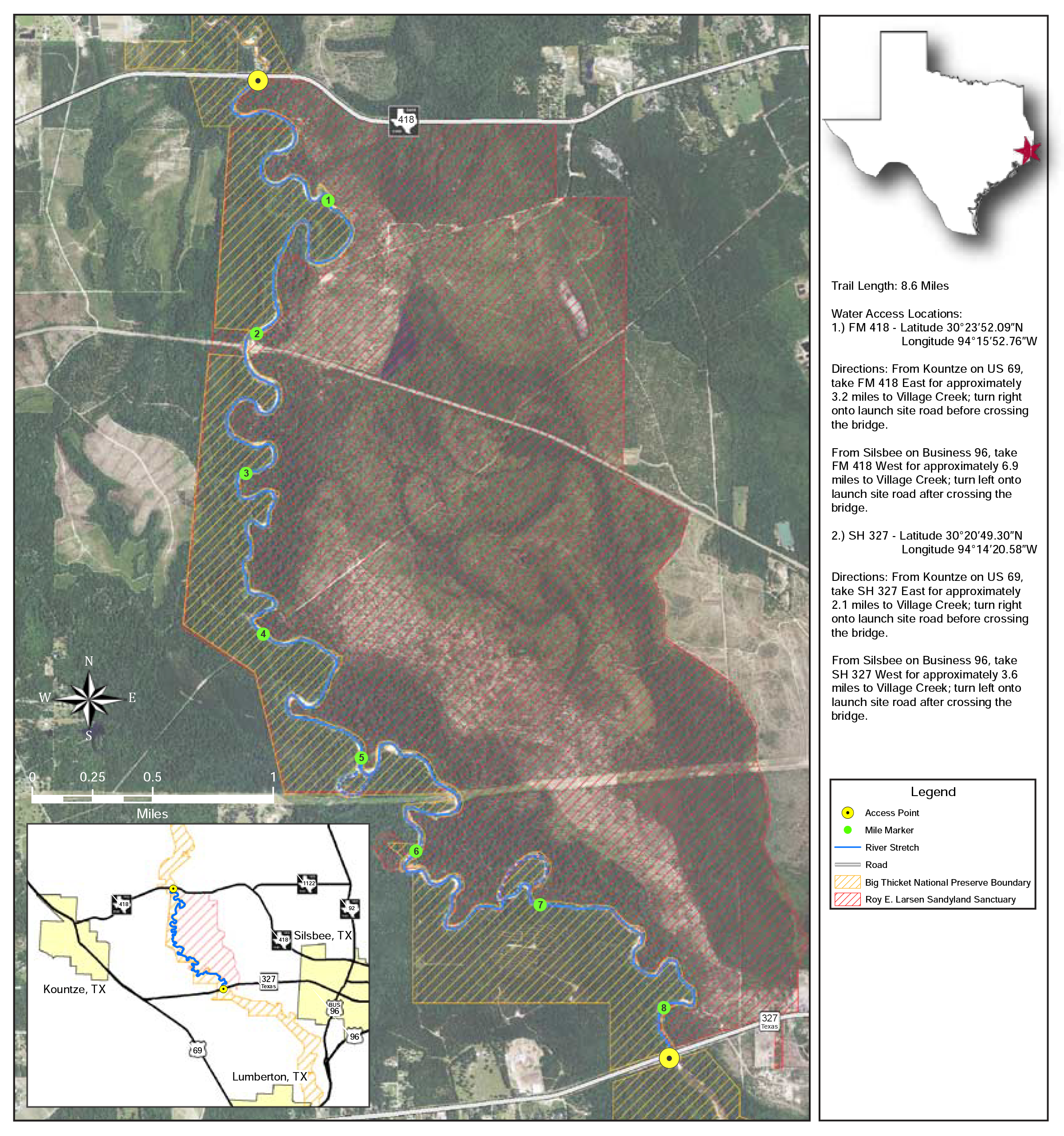
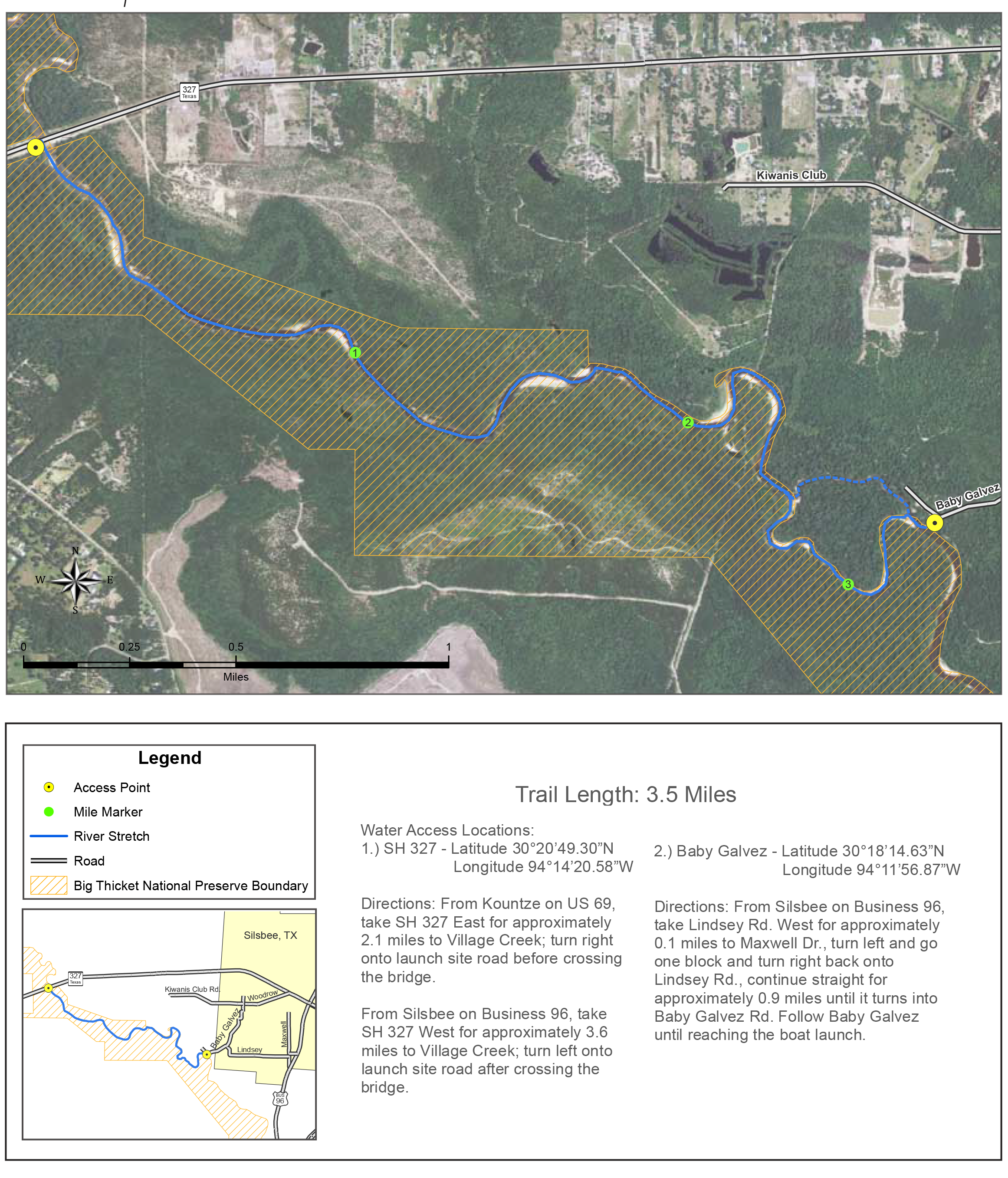
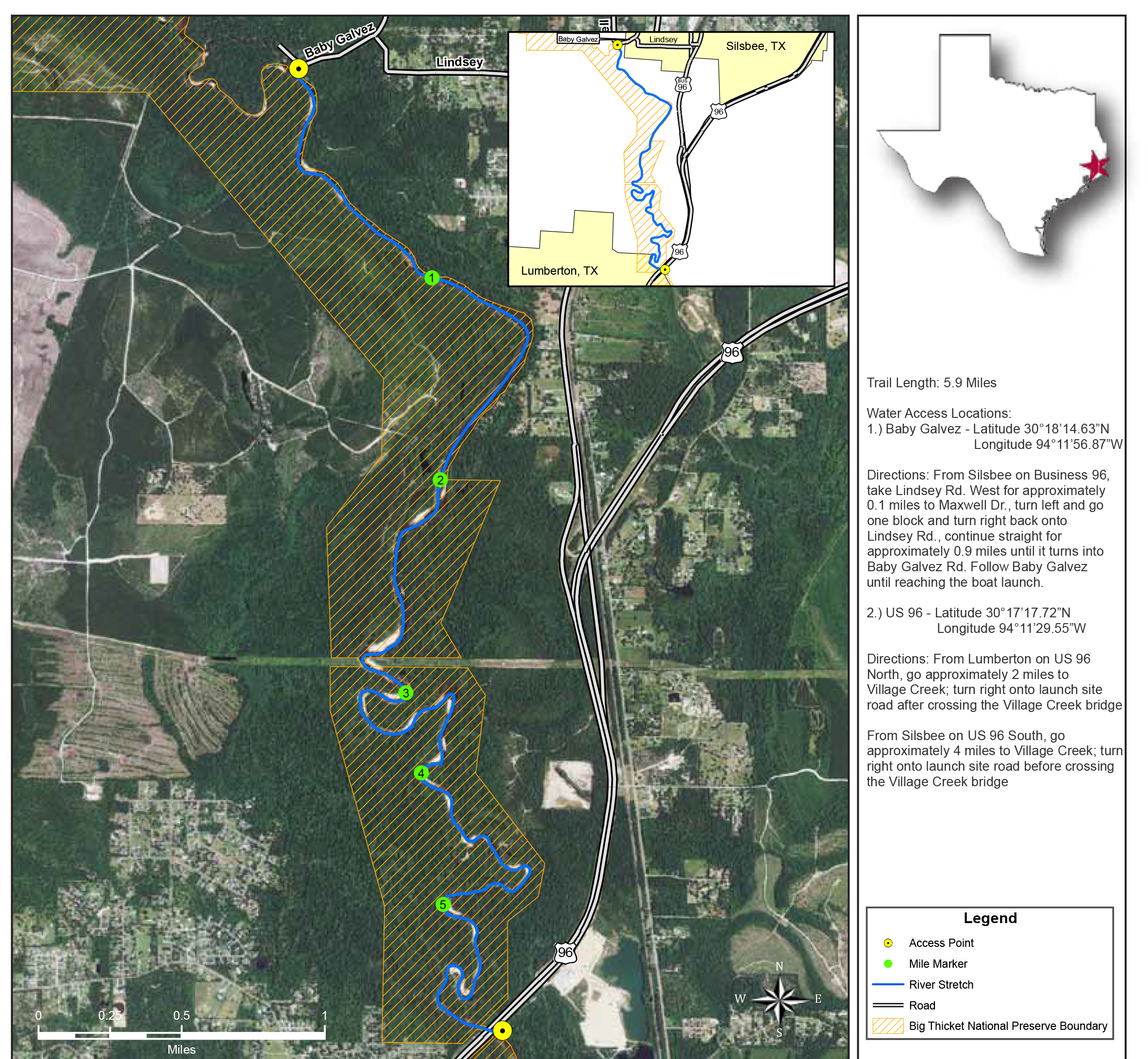
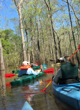
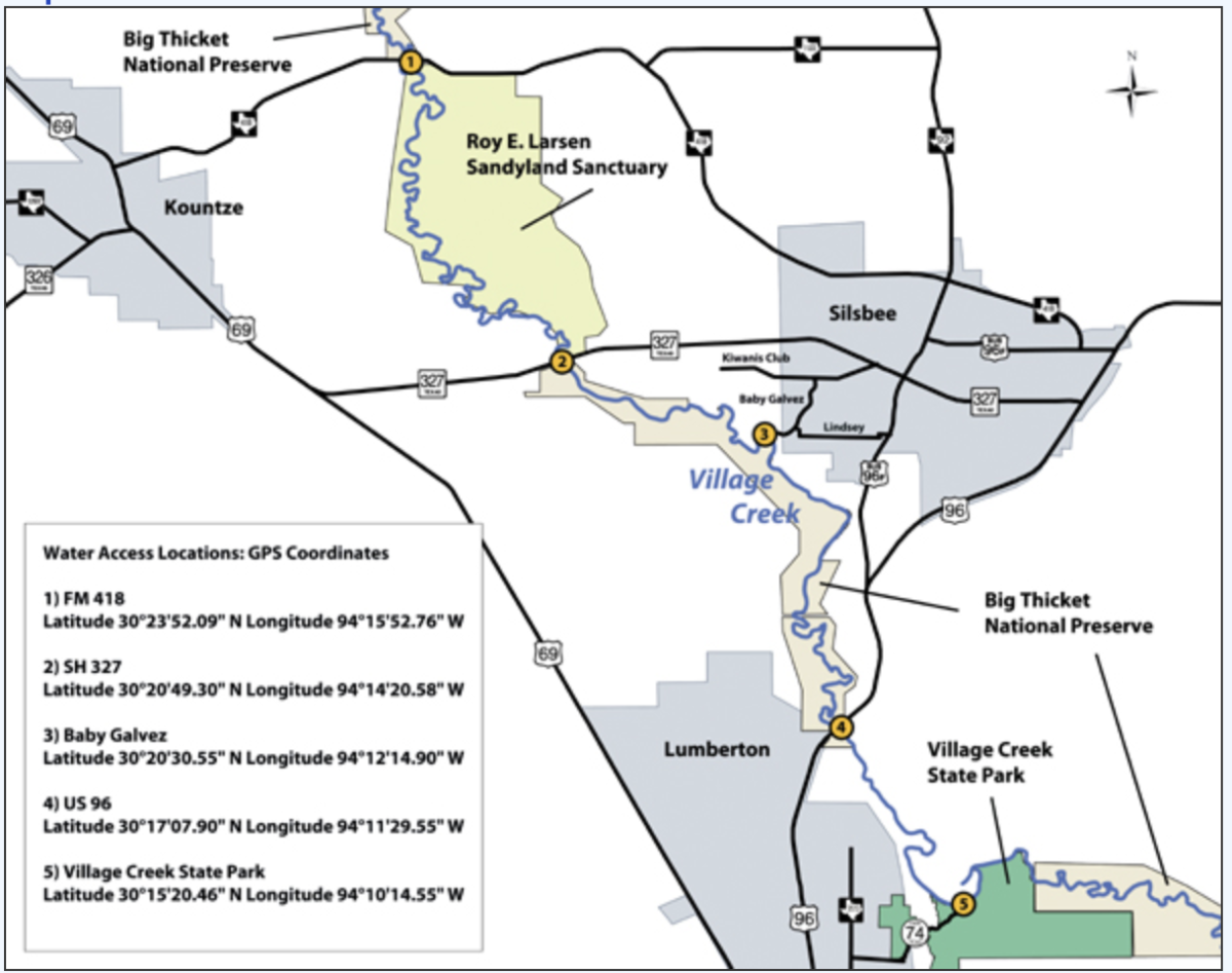
Village Creek Paddling Trail
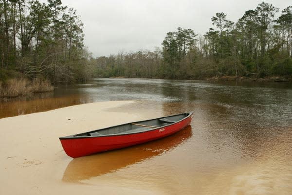
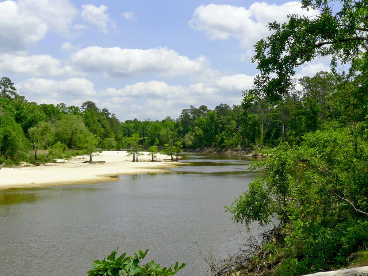
Part of the Big Thicket National Preserve, Village Creek State Park has multiple access sites to help you create the best float time for you, whether you are looking for an easy one-hour paddle or an all day outdoors experience. With beautiful white sandy beaches and sandbars, amazing wildlife diversity and tall East Texas trees, this beautiful trail is not to be missed.
- Trail Length: 21 miles
-
Estimate float times for each segment: FM 418 to SH 327 – 8.6 miles, ~4-6 hours, SH 327 to Baby Galvez – 2.1 miles, ~1-2 hours, Baby Galvez to US 96 – 7.1 miles, ~3-5 hours
-
Float Time: Segments can take 2- 5 hours depending on wind speed, water levels, and time spent exploring. You can't do the entire thing in a day, but overnight camping permits are available.
-
Difficulty: Easy - Moderate
What Makes it Unique:
Village Creek is a flat-water stream with several smaller streams, oxbow lakes, and sloughs connected to the creek. The park is part of the Big Thicket National Preserve and is home to a forest full of cypress swamps; water tupelo, river birch, mayhaw and yaupon trees; and baygalls and blackwater sloughs in the floodplain of the Neches River.
What You Can Expect:
Remote flatwater that's easy to navigate, enjoy the beauty and serenity of a secluded natural environment more than the thrill of raging whitewater. You'll weave through a dense forest canopy taking in the native birds, animals, and plantlife. There are three routes varying in length from 3.5-miles to 8.6-miles. Bald cypress, water tupelo, and black willow trees grow along the creek while pines, oaks, and over a hundred other tree species grow in the forests and bottomlands surrounding the creek.
Keep Your Eyes Peeled For:
The Big Thicket area is known as the biological crossroads of North America since more species of plants and animals occur in this area than any similar sized area of North America. Common wildlife encountered includes white-tail deer, raccoons, turtles, fish, snakes, freshwater mussels and the occasional otter or beaver. Although common to the Neches River watershed, alligators are rarely seen in the creek due to natural springs creating cooler water temperatures. Wildlife includes snapping turtles, white-tailed deer, diamondback water snakes, opossums, spring peepers, crickets, bull frogs and nine-banded armadillos. Birding enthusiasts will enjoy rain-loving wood ducks, egrets and herons, just to name a few of the 200+ species native to the Big Thicket.
How to Get There:
Village Creek has multiple access points.
1. FM 418 30° 23’ 52.09” N, 94° 15’ 52.76” W
2. SH 327 30° 20’ 49.30” N, 94° 14’ 20.58” W
3. Baby Galvez 30° 18’ 14.63” N, 94° 11’ 56.87” W
4. US 96 30° 17’ 17.72” N, 94° 11’ 29.55” W
To get to the FM 418 access site:
From Kountze on US 69, take FM 418 East; go approximately 3.2 miles to Village Creek; turn right onto launch site road before crossing the Village Creek bridge.
From Silsbee on Business 96, take FM 418 West; go approximately 6.9 miles to Village Creek; turn left onto launch site road after crossing the Village Creek bridge.
To get to the SH 327 access site:
From Silsbee on Business 96, take SH 327 West; go approximately 3.6 miles to Village Creek; turn left onto launch site road after crossing the Village Creek bridge.
From Kountze on US 69, take SH 327 East; go approximately 2.1 miles to Village Creek; turn right onto launch site road before crossing the Village Creek bridge.
To get to the US 96 access site:
From Lumberton on US 96 North, go approximately 2 miles to Village Creek; turn right onto launch site road after crossing the Village Creek bridge.
From Silsbee on US 96 South, go approximately 4 miles to Village Creek; turn right onto launch site road before crossing the Village Creek bridge.
Facilities:
Campsites include water and electricity, dump station, tent sites, showers, group facility, playground, hiking trails, canoe launch on Village Creek, pavilion, and picnic area.
While You're There: Try Fishing
The creek supports numerous species of fish including bass, crappie, catfish, and sunfish. Small lures such as jigs, plastic worms, spinner baits and light-line are recommended. Heavier line is recommended for catfish and gar. Live bait tends to work better due to low light conditions of the creek.
Good to Know:
Village Creek is a natural creek that is unrestrained by flood control dams or other human built structures. As such, the creek is readily influenced by rainfall runoff that may create temporary high flows. Heavy rains and high water can create dangerous conditions and deceivingly swift currents. Flood warnings and stream flow information is available to paddlers from NOAA (National Oceanic and Atmospheric Administration) or from the U.S. Geological Survey.