


- Home
- Things To Do
- Parks & Outdoors
- Parks
- Tyrrell Park
- Tyrrell Park Nature Center
- Gift Shop
- Big Thicket
- The Best Hiking Trails in the Big Thicket
- Water Activities
- Lakes and Rivers
- Neches River Boat Tours
- Kayaking and Canoeing in Beaumont
- Horseback Riding
- Botanical Gardens
- Beaumont in Bloom
- Fishing & Hunting
- Fishing Charters in Beaumont
- Golf
- Camping in Beaumont
- Agritourism
- Hiking
- Biking
- Beaucycles
- Birding
- Cattail Marsh
- Big Thicket
- Birding Package
- Beaumont Birdies
- Birder Mailing List
- Anahuac
- High Island
- Bolivar Flats
- Sabine Woods
- Galveston Island
- Creole Nature Trail
- Swamps & Gators
- Arts & Culture
- Performing Arts/Theater
- Galleries & Museums
- Murals and Visual Art
- 10 Best Instagram Spots
- SETX Selfie Scavenger Hunt
- Museums & Historic Sites
- Top Historic Spots
- Spindletop
- Museums
- Historic Homes
- Entertainment & Nightlife
- Casinos & Gaming
- Happy Hour
- Live Music
- Movie Theaters
- Bowling & Skating
- After Hours
- Sawdust Saloon
- Shopping
- Antiques
- Boutiques
- Gift Guide
- GoBeau Gifts
- Bolivar Beach
- Cattail Marsh
- Web Cam
- Wetlands Education Center
- Volunteer
- Roadside Attractions
- Things to Do with Kids
- Parks & Playgrounds
- Bowling & Skating
- Things to Do for Couples
- Girlfriend Getaway Ideas
- Things to Do Solo
- Dog-Friendly Attractions
- Beaumont Bucket List
- Bucket List Challenge
- LGBTQ Guide
- Geocaching
- 24-Hour Itinerary
- Wheelchair-Accessible Guide
- Multigenerational Itinerary
- Black History and Culture
- Home
- Restaurants
- Eat Local #EATBMT
- BBQ
- Burgers
- Mediterranean & Indian
- Tex-Mex
- Margaritas
- Pasta
- Pizza
- Sandwiches
- Seafood
- Street Tacos
- Sushi
- Vietnamese
- Family Friendly Restaurants
- Bars, Pubs & Breweries
- Breweries
- Wineries
- Dive Bars
- Sports Bars
- Outdoor Bar Scene
- Live Music
- Bakery & Cafe
- Happy Hour
- Best Beaumont Bites
- Patio Restaurants
- A-Z: A South Texas Cajun Food Guide
- Crawfish Spots
- Where to Find Gumbo
- Instagram Foods
- Favorite Foodie Restaurants
- Cajun Trail
- Cajun Trail FAQ
- Home
- Plan
- Visitors Guide
- Top 10 Reasons to Visit
- Trip Ideas
- Texas History Trail
- Faith Trail
- Black Gold Trail
- Pioneer Trail
- Adventure Seekers
- Festival Lovers
- 24-Hour Guide
- Nature Trail
- Insider's Guide
- Visitor Center
- Maps
- Transportation
- Jack Brooks Airport
- Weather
- eNewsletter
- Webcams
- FAQ
- Deals
- GoBeau
- Home
- Events
- Event Calendar
- Annual Events
- February: Mardi Gras of Southeast Texas
- March: Taste of the Triangle
- March: South Texas State Fair & Rodeo
- April - 409 Weekend
- April- Neches River Festival
- May- Neches River Rally
- October: Oktoberfest
- October: Dogtober Fest
- October: Museum Madness
- October- The Haunted Hotel
- December: Main Street Market
- December: Holidays in Beaumont
- December: Christmas in Boomtown: City in Lights
- Beaumont Mardi Gras
- Carnival
- Concerts
- Mardi Gras Attractions
- Capes and Crown 5K
- How to Get Involved
- Classic Movie Nights
- Farmers Market
- Neches River Boat Tours
- Submit Your Event
- Event Submission Policy
- Recurring Events
- Downtown Beaumont Junk Days
- Larry's Old Time Trade Days
- I-10 Flea Market
- Events This Weekend
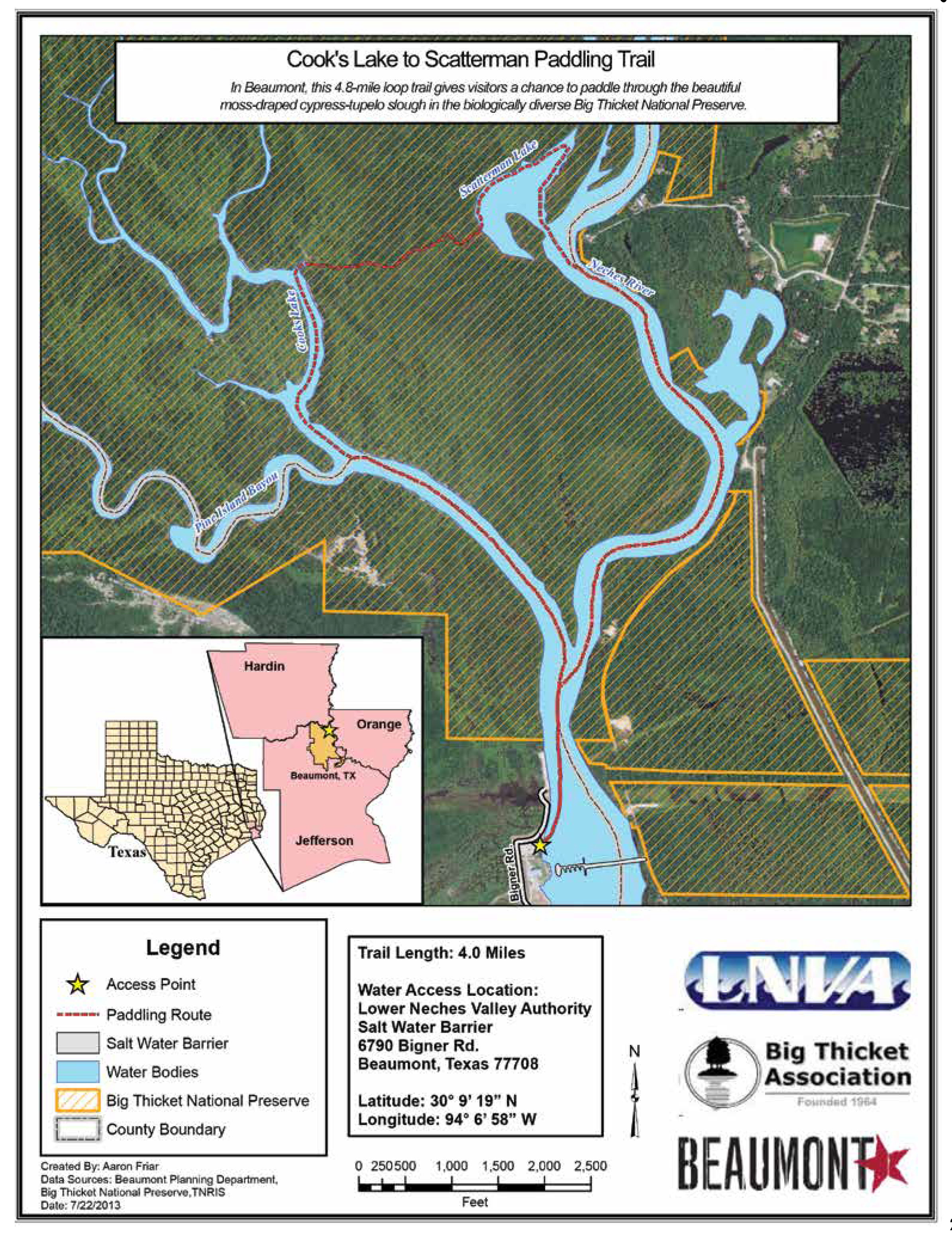
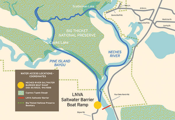
Cook’s Lake to Scatterman Paddling Trail
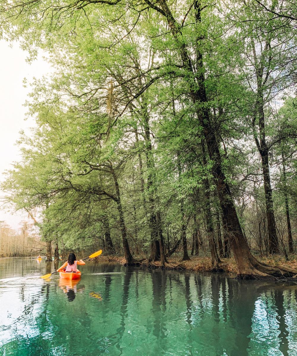
This 4.8-mile loop trail gives visitors a chance to paddle through the beautiful moss-draped cypress-tupelo slough in the biologically diverse Big Thicket National Preserve. It is also home to the Neches River Rally, a group paddling event held each September.
-
Trail Length: 4.8 mile loop
-
Float Time: ~2- 5 hours depending on wind speed, water levels, and time spent exploring
-
Difficulty: Easy - Moderate
What Makes it Unique:
This federally protected area stretches north and west of Beaumont across 112,250 acres of land and water, and it preserves the area’s unusual combination of habitats that converged here during the last ice age. Along the Neches River, which serves as the preserve’s primary waterway, visitors can find desert plants like cacti thriving near swamp species like cypress. Additionally, four of the five carnivorous plants native to the U.S. can be found within the preserve’s boundaries.
What You Can Expect:
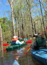
The paddling trail takes paddlers from the LNVA Saltwater Barrier Boat Ramp up the Neches River taking the left fork to Pine Island Bayou and into Cook’s Lake. This looped paddling trail gives paddlers a chance to paddle through a moss-draped cypress/tupelo slough in the biologically diverse Big Thicket National Preserve to Scatterman Lake and back to the Neches River. The seemingly short trail can actually become an all-day adventure since Cook’s Lake and Scatterman Lake are abandoned river channels that have become oxbow lakes which are fun to explore. This trail is relatively flat and very close to sea level giving paddlers a fairly easy paddle upstream; flow is generally quite low.
From the boat ramp, the trail travels upstream along calm, flat water to the junction of the Neches River and Pine Island Bayou, where it then veers left into the bayou. Paddlers will begin seeing the distinctive “knees” of the swamp’s cypress forest on their left. The trail forks again at Cook’s Lake, and here paddlers will want to stay to the right. Cook’s Lake stretches into the slough as an open area of water, and boaters can spend some time exploring the varied shoreline. After turning around, boaters will put the swamp to their left and begin looking for the blue-tipped plastic poles that indicate the trail’s path through the marsh. This section offers the most challenging, as boaters may need to paddle against the current through a tangled maze of underwater stumps. On the other side, oxbow-shaped Scatterman Lake offers flat water once again, and from here paddlers can enjoy a leisurely float back to the starting boat ramp.
Keep Your Eyes Peeled For:
The riparian corridor of the Neches River supports a great diversity of plant and animal life along the river and beyond the banks. Birds spotted here include: herons, egrets, cormorants, barred owl, belted kingfisher, osprey, pileated woodpecker, prothonotary warbler, roseate spoonbill, swallow-tailed kite, and wood duck. A variety of plants can be found along the river as well, including bald cypress, black tupelo, loblolly pine, oaks, river birch, ferns, cardinal flower, spider lilies, and Neches River rose mallow. Common wildlife encountered include bullfrog, leopard frog, opossum, red-eared slider, raccoon, river otter, American alligator, alligator snapping turtle, and a variety of water snakes.
How to Get There:
Lower Neches Valley Authority (LNVA) Saltwater Barrier Boat Ramp
6790 Bigner Road
Beaumont, TX
(DD) 30.15523, -94.11588
From US Highway 69/96 in Beaumont take the Lucas Drive Exit and head east approximately one mile. Turn left heading North on Bigner Road and continue straight on Bigner Road until reaching the boat ramp in approximately 1.5 miles.
Facilities:
The primary trailhead is located at the LNVA Saltwater Barrier. The Lower Neches River Authority operates and maintains the Barrier which was completed in 2003. The public boat ramp, public restrooms, picnic area, walking trail, and stocked fishing ponds provides the public world class facilities as well as increased access to the Neches River and the Big Thicket National Preserve.
While You're There: Try Fishing
The river and oxbow lakes support black (largemouth and spotted) bass. A favorite fish eaten by locals is catfish and blue, flathead (also called yellow), and channel catfish are present. This system supports a variety of sunfish, including bluegill, green, and longear sunfish. Spotted, alligator, and long-nose gar all inhabit these waters. Small lures such as jigs, plastic worms, spinner baits and lightline are recommended.
Local Operators:
Services offered: Kayak Rentals, Canoe Rentals, Shuttle Services, Maps, Paddles, Lifejackets, Guided or Self Guided Day Trips and Overnight Trips. Services will vary with each outfitter.
Big Thicket Outfitters 115 Connolly Road, Vidor, TX 77662 (409) 786-1884; bigthicketoutfitters.com
Eastex Canoe Trails/Eastex Outfitters 50 Turtle Creek Dr., Silsbee, TX 77656 (409) 385-4700; eastexcanoes.com
Sharp’s Canoe & Kayak Rentals 8632 Billy’s Drive, Silsbee, TX 77656 (409) 385-6241 • Shawl Canoe School Mary Carter; (409) 791-0040
Contact Info:
Big Thicket National Preserve Visitor’s Center (409) 951-6700 www.nps.gov/bith/index.htm
Big Thicket Association/Neches River Adventures (Eco Tours on-board the Ivory Bill) (409) 651- 5326 www.bigthicket.org
Good to Know:
Big Thicket National Preserve offers FREE ranger-led paddling trips and will provide the canoes/kayaks, paddles, and life jackets (PFDs) along with instruction. Check their calendar for upcoming dates and more information.